Contents
Index
Convert Raw File to ACS Format
Raw File
Enter the name of the raw data file to be converted. This will usually be a .RAW, .GRE, .SDR or similar file type. Use the Browse button to search the disk to select the file necessary.
Data Format
Enter the data format of the file, this is the data recorder file format. The system supports the following data recorder formats:
Sokkia SDR2, SDR20, SDR21, SDR31, SDR33 formats - Details
Leica TPS1100 format (GSI16) - Details of data format.
Leica GRE3/4 format (GSI8) - Details of data format.
Geodimeter - Details of data format.
Nikon - Details of data format.
This is IMPORTANT, if the program tries to interpret say SDR2 data as GRE format, it will probably get gibberish or nothing.
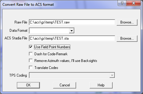
ACS Stadia File
Enter the name of the output ACS file, this will be the job name with a .STA extension. This file will contain the stadia data in ACS format and will form the master copy of the field data that you will edit and store as the reference data for the job. Use the Browse button to select the output directory and filename if they are different.
Use Field Point Numbers
Check the this box to force the program to insert the field point numbers onto the 25 records in the ACS Stadia file.
Dash For Code-Remark
Check this box to force the program to join the code field and the remark fields together and then re-separate them using the '-' character. For example,
Code = "TREE102"
Remark = "GUM3S7H-Dead Tree"
After the joining and separation:
Code = "TREE102GUM3S7H"
Remark = "Dead Tree"
This feature allows you to have longer code fields than the data recorder may allow you to type in. The program allows and code or remark field to be up to 80 characters in length.
Remove Azimuth Values
Click this check box to use Backsights as opposed to Azimuth Values.
Translate Codes
If the data type is 'Leica GRE3' you can check this box to instruct the program to look up the code in the GeoSurvey_config.xml file and attempt to translate it. If the translation succeeds, the translated value will be inserted into the output stadia file. If the translation fails, the original code is inserted into the output file.
Code translation
For more infro click here
Leica Coding - 41=Point Code
The 41-45 words in the Leica GSI file can be used for several different purposes.
Station Setup Information
41 = 1
42 = Setup station id
43 = Height of instrument
44 = Height of target
45 = Observed station
Target Height
41 = 2
42 = Height of Target
Point Code Information
41 = point code
Tick this box if you want the 41 word treated as a point code, un-tick the box if you want the 41-45 words treated as a station setup or height of target value.